STEP 01
Reconnaissance & Records Review
Review available cadastral information, inspect site access and identify boundary evidence.

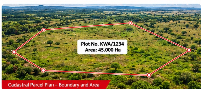
Boundary survey, parcel demarcation and area determination for Plot No. KWA/1234 in Kwale, Kenya.
Skymap Africa Ltd was engaged by Joban Group Limited to undertake a cadastral survey for Plot No. KWA/1234 at Kwale, Kenya. The assignment focused on tracing and verifying parcel boundaries, checking boundary beacons, determining parcel area and preparing a cadastral plan with a coordinate schedule.
The survey workflow combined field reconnaissance, GNSS/RTK observations, total station measurements and boundary verification, with data processing and plan preparation to support land-development planning.
| Project Information | |
|---|---|
| Client | Joban Group Limited |
| Plot Number | KWA/1234 |
| Location | Kwale, Kenya |
| Surveyed Area | 450,000 m² (45.000 ha) |
| GNSS/RTK Accuracy | ±10 mm horizontal, ±5 mm vertical (as provided) |
| Datum / Projection | Arc 1960 / UTM Zone 37S |
| Survey Date | 28 October 2026 |
Survey activities were organized to establish the available boundary evidence, record survey observations and prepare the parcel plan and supporting schedules.
Review available cadastral information, inspect site access and identify boundary evidence.
Confirm survey control and the coordinate reference system used for observations.
Observe boundary points using GNSS/RTK and total station methods where appropriate.
Check coordinates, compute parcel area and compile the cadastral plan and report.
The figures below reproduce the values shown in the supplied report preview. Verify against the signed survey records before official use.
| Point ID | Easting (m) | Northing (m) |
|---|---|---|
| B1 | 528,467.235 | 9,268,421.779 |
| B2 | 529,134.871 | 9,268,589.415 |
| B3 | 529,846.019 | 9,268,257.456 |
| B4 | 529,971.632 | 9,267,741.906 |
| B5 | 529,602.117 | 9,267,085.430 |
| B6 | 528,946.550 | 9,267,033.808 |
| B7 | 528,488.296 | 9,267,418.623 |
| B8 | 528,334.627 | 9,267,975.241 |
Two key visuals highlight the reported parcel outline and a typical instrument setup used during cadastral fieldwork.

Subject to the agreed scope and applicable cadastral requirements, the report package may include:
Parcel boundary representation, beacon positions and supporting plan information.
Boundary point identifiers with easting and northing values in the stated reference system.
Methodology, field observations, area computation, findings and supporting photographic record.
Talk to Skymap Africa about boundary verification, GNSS/RTK surveys and cadastral mapping.