
STEP 01
Reconnaissance & Records Review
Review available cadastral information, inspect site access and identify boundary evidence.

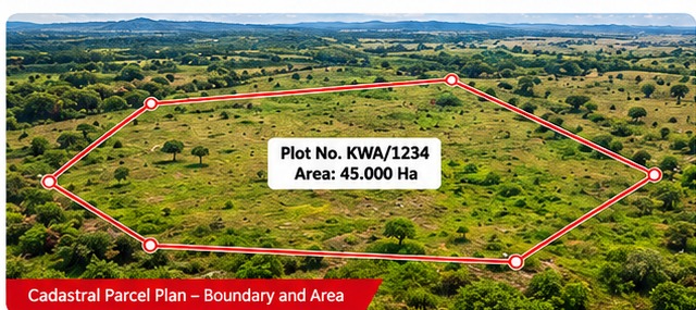
Boundary survey, parcel demarcation and area determination for Plot No. KWA/1234 in Kwale, Kenya.
Skymap Africa Ltd was engaged by Joban Group Limited to undertake a cadastral survey for Plot No. KWA/1234 at Kwale, Kenya. The assignment focused on tracing and verifying parcel boundaries, checking boundary beacons, determining parcel area and preparing a cadastral plan with a coordinate schedule.
The survey workflow combined field reconnaissance, GNSS/RTK observations, total station measurements and boundary verification, with data processing and plan preparation to support land-development planning.
| Project Information | |
|---|---|
| Client | Joban Group Limited |
| Plot Number | KWA/1234 |
| Location | Kwale, Kenya |
| Surveyed Area | 450,000 m² (45.000 ha) |
| GNSS/RTK Accuracy | ±10 mm horizontal, ±5 mm vertical (as provided) |
| Datum / Projection | Arc 1960 / UTM Zone 37S |
| Survey Date | 28 October 2026 |
Survey activities were organized to establish the available boundary evidence, record survey observations and prepare the parcel plan and supporting schedules.
Review available cadastral information, inspect site access and identify boundary evidence.
Confirm survey control and the coordinate reference system used for observations.
Observe boundary points using GNSS/RTK and total station methods where appropriate.
Check coordinates, compute parcel area and compile the cadastral plan and report.
The figures below reproduce the values shown in the supplied report preview. Verify against the signed survey records before official use.
| Point ID | Easting (m) | Northing (m) |
|---|---|---|
| B1 | 528,467.235 | 9,268,421.779 |
| B2 | 529,134.871 | 9,268,589.415 |
| B3 | 529,846.019 | 9,268,257.456 |
| B4 | 529,971.632 | 9,267,741.906 |
| B5 | 529,602.117 | 9,267,085.430 |
| B6 | 528,946.550 | 9,267,033.808 |
| B7 | 528,488.296 | 9,267,418.623 |
| B8 | 528,334.627 | 9,267,975.241 |
Two key visuals highlight the reported parcel outline and a typical instrument setup used during cadastral fieldwork.

Subject to the agreed scope and applicable cadastral requirements, the report package may include:
Parcel boundary representation, beacon positions and supporting plan information.
Boundary point identifiers with easting and northing values in the stated reference system.
Methodology, field observations, area computation, findings and supporting photographic record.
Frequently asked questions
• Mutation Surveys: Subdividing a land parcel into two or more parts.
• New Grant Surveys: Establishing land for new allocations or leases.
• Amalgamation: Combining two or more adjacent parcels into a single title.
• Sectional Property Surveys: Mapping multi-unit or apartment structures under the Sectional Properties Act.
• Wayleave & Easement Surveys: Delineating access or utility corridors.1. Title Search: Conduct a search at the land registry or online via Ardhisasa to verify ownership and encumbrances.
2. Registry Index Map (RIM): Obtain the RIM and historical survey records from the Survey of Kenya.
3. Scheme Preparation: A physical planner drafts a subdivision scheme for PPA1 and PPA2 approvals with the county government.
4. Field Survey: A licensed land surveyor visits the ground to confirm or place boundary beacons using GPS or total stations.
5. Mutation Forms & Authentication: Mutation forms are signed, submitted, and authenticated by the Director of Surveys, leading to new parcel numbers and updated title issuance.• Fixed Boundaries: Accurately measured and coordinated using mathematical bearings and distances, with corner points marked by permanent concrete beacons or iron pegs. Any lost beacon can be precisely re-established. These require examination and authentication by the Director of Surveys.
• General Boundaries: Boundaries defined approximately by physical features on the ground—such as hedges, ditches, walls, or fences—rather than exact mathematical coordinates. Common in first-registration rural areas under land adjudication processes.
• Fixed-General Boundaries: A hybrid system introduced to upgrade or convert general boundaries into fixed coordinates in areas where land values and market appreciation have risen significantly.1.Proof of Ownership:
• Original Title Deed or Certificate of Lease for the parcel.
• Official Land Search (CR12 / Form RL 26) conducted recently (usually within the last 6 months) to confirm the registered owner and check for encumbrances or cautions.
2.Personal Identification:• Clear copy of the registered owner’s National ID or Passport.
• Copy of the owner’s KRA PIN Certificate.3.Rates & Statutory Clearance:• Rate Clearance Certificate (or latest land rates receipt) from the respective County Government showing no outstanding arrears.
4.Authorization & Instruction:• Signed Letter of Instruction / Authorization from the registered owner granting the licensed surveyor permission to act on their behalf.
5.Planning & Board Approvals:• PPA1 and PPA2 physical planning application and approval forms.
• Land Control Board (LCB) Consent (mandatory if the land is agricultural).
• Mutation Forms (signed in triplicate by the landowner and the licensed surveyor).
• Registry Index Map (RIM) or authentication slips obtained from the Survey of Kenya or via the digital Ardhisasa
6.Special Estate Documents (If Applicable):• Grant of Probate, Letters of Administration, or spouse consent if the registered owner is deceased or the property is family/matrimonial land.
Talk to Skymap Africa about boundary verification, GNSS/RTK surveys and cadastral mapping.